Map - Artifacts
Image
Copyright
For permission or reproduction for this image, use the photographic application and guidelines here.
Description
3 rolled maps of China
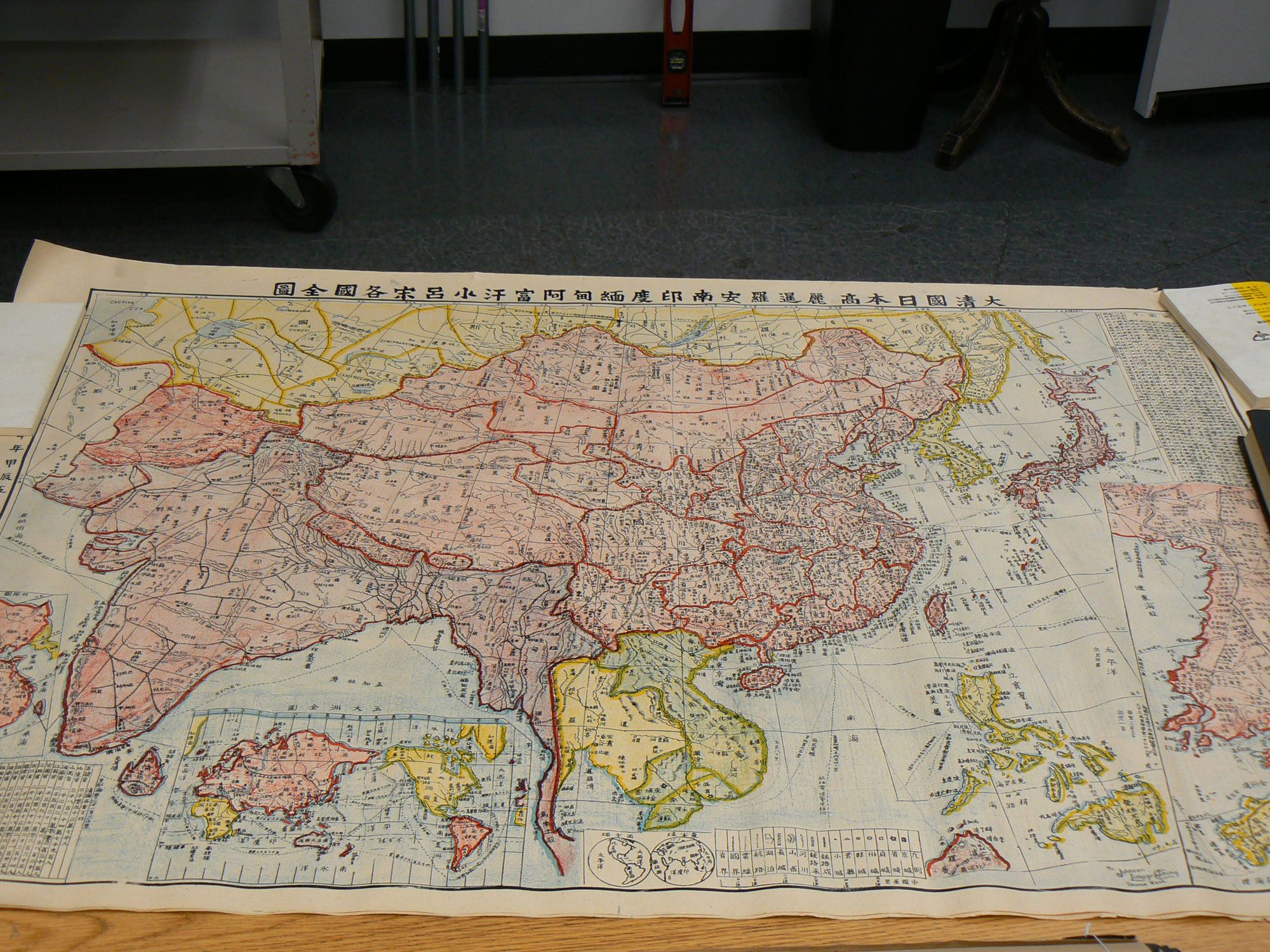
A & B: Two Identical Maps of Asia in Chinese C
Large maps shows various countries in Asia in yellow, red, green and blue. Two inset maps of Manchuria and one of the world. There is a chart in upper left and lower right, one explains the map and the lower one shows the population of China, each province, area, and total area: 415,000,000; includes 18 provinces, 3 northeast territories, Mongolia, Tibet and Xin Jian areas. Chinese characters along the top "Map of China (Qing), Japan, Korea, Siam, Vietnam, India, Burma, Afghanistan and Philippine Islands" and down the left side "Map made by ? in May, 1904". At the bottom of the center in blue ink on white are two globes and a map legend. To the right of this "Johnson Lithographing Co., Tacoma Wash." is printed. Paper is turning yellow and is split in several places.
C: Map of Toisan area, H: 41", W: 29.25", green pink, yellow and blue printed on white paper showing Toishan and surrounding areas with inset map of Sun Ning and the rail road. another inset map locating Toishan in China, and one of the Hong Kong harbor. Pink box with columns of Chinese characters on right side gives the history of Xin Ning County; Summary: The Xin Ning County belonged to Xin Huei (Gu Gong State) before 1628-1644 (the period of the latest Ming emperor). The county has existed for about 270 years. Then there is a geographical description of Xin Ning County and its vicinity. There was a fight between two groups "tu ren" and "ke ren" from 1853 to 1862. Ke ren kills several thousands of Tu ren during this period. In 1862 the governor finally got involved and tried to settle the fight. It took several months, from Jan. to Aug. Finally, the Ke ren group surrendered. Since then, the Ke ren group lived in the souther area, and the Tu ren group lived in the northern area. The two areas is separated by a mountain range. Chinese characters in black at the top and left hand side "Map of Xin Ning county and vicinity, Guang Dong province, China" dated January, 1908. Near lower left is printed "Lithographed by Tucker Hanford Co. Seattle".
Object ID
1997.055.078